
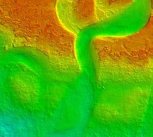
AN ANCIENT riverbed has come to light off Dorset’s coast in an exciting new survey which has revealed a wealth of underwater treasures.
Seabed mapping has provided fascinating images including a clearly visible meandering river channel cutting through bedrock eight miles south of Lulworth Cove.
According to Professor Vince May of Bournemouth University the area would have been dry from about 185,000 years ago, then the sea level rose before falling again 70,000 years ago and covering it again 12,000 years ago.
“It’s possible that we are looking at two channels – an older one from the earlier period which was reworked and deepened with the higher runoff from the later period,” he said.
“It puts current concerns about sea level rise in context and suggests that we could rename Weymouth.
“This is just a glimpse of the data collected so far – there will be so much we can learn when it’s all in.”
The stunning detail of shipwrecks, rugged cliffs and massive gravel dunes has been revealed in the first phase of a £300,000 project funded by Viridor Credits, which puts the county at the forefront of marine mapping in the UK.
The Dorset Integrated Seabed study (Doris), will ultimately produce a detailed seabed habitat map covering more than 800sq km from Swanage to Abbotsbury.
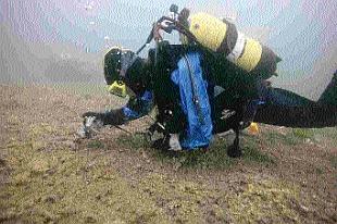
A high resolution acoustic survey was completed earlier this year and Southampton-based Seastar Surveys will shortly start work on the next phase with divers recording seabed habitats and matching them to the data.
The project involves Dorset Wildlife Trust, the Maritime and Coastguard Agency and Channel Coastal Observatory, who will each use the maps for their own purposes.
Peter Tinsley, marine conservation officer for DWT, said there had never been a greater demand for reliable seabed information, with the Marine Bill soon to go through its second reading in the House of Commons.
“This should lead to more sensible and sustainable use of our marine resources, for the benefit of marine wildlife,” he said.


Comments: Our rules
We want our comments to be a lively and valuable part of our community - a place where readers can debate and engage with the most important local issues. The ability to comment on our stories is a privilege, not a right, however, and that privilege may be withdrawn if it is abused or misused.
Please report any comments that break our rules.
Read the rules hereLast Updated:
Report this comment Cancel